


Volver 1/1
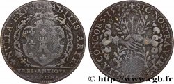
fjt_016047 - VILLES DE BOURGOGNE Charles de Trudaine 1713

No disponible.
Artículo vendido en nuestra tienda (2009)
Precio : 35.00 €
Artículo vendido en nuestra tienda (2009)
Precio : 35.00 €
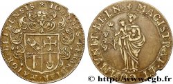
Tipo : Charles de Trudaine
Fecha: 1713
Metal: cobre rojo
Diámetro: 31 mm
Eje de acuñación: 6 h.
Canto: lisse
Grado de rareza: R2
N° en los catálogos de referencia :
Anverso
Descripción del anverso: Armes de Charles de Trudaine.
Reverso
Titulatura del reverso: IAM QUANTUS IN ORTU 1713.
Descripción del reverso: Le soleil levant.
Traducción del reverso: Déjà si grand au lever.
Comentario
Pas de biographie en ligne pour notre personnage mais un intéressant développement à http://pagesperso-orange.fr/jac.deschard/Pomiera1.html
En 1743, la nomination de Daniel Charles de TRUDAINE comme "ministre de l'équipement" va placer un homme capable et énergique aux commandes pour vingt six ans. Dès sa nomination, il voulut presser la réalisation des voies prévues par l'instruction de 1738.
Pour cela il lui fallait réunir deux préalables : la qualification indiscutable des ingénieurs et un lever des plans de routes permettant la rectification des tracés, la prévision des voies à créer et la délimitation des zones des paroisses corvéables.
Pour réaliser ces deux objectifs il créa l'Ecole des Ponts-et-Chaussées en 1747 et un bureau de dessinateurs pour exécuter cet énorme travail cartographique.
Est-il utile de rappeler que la première carte générale moderne de la France est celle de Cassini commencée vers 1750 et terminée seulement en 1815 et qui fut la première carte établie en s'appuyant sur une triangulation géodésique.
No online biography for our character but an interesting development at http://pagesperso-orange.fr/jac.deschard/Pomiera1.html In 1743, the appointment of Daniel Charles de TRUDAINE as \\\"Minister of Equipment\\\" will place a capable and energetic man in command for twenty-six years. From the moment of his appointment, he wanted to hurry the construction of the roads planned by the instruction of 1738. To do this, he needed to meet two prerequisites: the indisputable qualification of the engineers and a survey of road plans allowing the rectification of the routes, the forecasting of the roads to be created and the delimitation of the areas of the corvéable parishes. To achieve these two objectives, he created the School of Bridges and Roads in 1747 and a draftsman's office to carry out this enormous cartographic work. Is it useful to recall that the first modern general map of France is that of Cassini, begun around 1750 and completed only in 1815 and which was the first map established based on geodesic triangulation?
Historial
VILLES DE BOURGOGNE
 Informar de un error
 Imprimir la página
 Comparte mi selección
 Haz una pregunta
 Consignar / vender
Artículos relacionados
 Descriptivo
Productos que has visto recientemente

20 Francs DEBUSSY Modifié FRANCIA 1997 F.66ter.02A60 EBC
7.00 €
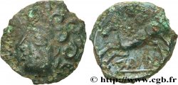
GALLIA - BITURIGES CUBI (Región de Bourges) Bronze IIAROS aux trois annelets po
150.00 €
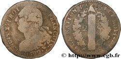
LOUIS XVI 2 sols dit "au faisceau", type FRANCOIS 1792 Arras BC+
13.00 €

MONEDEROS LOUIS, MONEDEROS Porte-louis, Cannelures MBC+
30.00 €
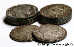
Lot de 10 pièces de 10 francs Turin, ARGENT 1929 - 1939 F.360/- lote
52.00 €
SUDÁFRICA 2 1/2 Shillings président Kruger 1893 MBC
120.00 €